Mucky march to Marcy Dam

The South Meadows register for the Marcy Dam truck trail is seen on Monday, April 14. (News photo — Chris Gaige)
LAKE PLACID — Following last week’s icy escapade up to the 2,939-foot Mount Van Hoevenberg, I decided to play it low and scout out a trail that stuck below the elevation where the ice began cropping up then.
Despite my best efforts, I was not completely spared from the ice — a reminder that snow and ice is still well entrenched throughout much of the backcountry, even at the relatively lower elevations. Fortunately, the 0.3 miles of snow and ice I traversed this week happened to be on a generally level stretch of trail, making things somewhat more manageable — although I would still strongly recommend folks pack microspikes.
When I emerged from the woods after the hike, I was caked in mud up to my ankles, with speckles extending up to my knees. To be fair, I was trail jogging for much of the hike out and the mud was hardly a surprise — April is especially notorious for it.
I had made peace with the mud before I even knew what trail I would find myself on, and I planned accordingly. I consulted trusty guidebooks in preparation for this week’s column. My eager eyes dotted around the map. Most of the routes were no-gos right off the bat.
Nightmares swirled in my mind — icy ledges, roaring river crossings, mushy rotten snow — the list goes on. While I am lucky to say that I’ve summited all of the High Peaks at one point or another, and loved doing so, mid-April just strikes itself, in my opinion, as a horrendous time to even contemplate such an adventure.

Signs for the South Meadow trail and the Phelps Brook Lean-to are seen near Marcy Dam on Monday, April 14. (News photo — Chris Gaige)
As I continued glancing, doors kept closing. Suddenly, a light bulb flicked on. It was a destination that I had passed through many times. I get it, I get it — the headline gave it away. Marcy Dam is a hiker’s hub of sorts when venturing into the High Peaks. Several popular trails leading to as Marcy, Phelps and Colden — among other High Peaks — merge and diverge from each other, depending on your direction of travel, in the area.
I struggle to put a digit on the number of times I have been to Marcy Dam. At least a dozen, perhaps more. That said, all of those trips originated from the Adirondak Loj at Heart Lake.
There is another route to Marcy Dam, known as the Marcy Dam truck trail, interchangeably known as the South Meadow trail. The mileage is a bit longer than starting from Heart Lake, making this route generally less traveled.
Since I planned on just going to the dam, and wasn’t looking to conserve distance as I would on a longer hike into the High Peaks, I figured it was the perfect opportunity to check out a trail I had never set foot on.
The trail begins at the intersection of South Meadows Road and Adirondack Loj Road — about 4 miles south of the intersection with state Route 73. Note that parking is limited, as South Meadows Road, which offers more room for parking during the summer months, is a seasonal road and is closed through mud season, leaving only a small trailhead along the Adirondack Loj Road.
Mount Colden, left, and Avalanche Mountain are seen from Marcy Dam in the High Peaks Wilderness Area, as well as part of Wright Peak’s shoulder on the right, on April 14. (News photo — Chris Gaige)
The trail, as you may have gathered from its dual name as a truck trail, is abundantly wide — for a hiking trail. Much of the route does not have formal colored discs marking it, like most other are trails do. While there are several junctions where it is important to read the signage and make sure you’re on the correct path, the South Meadows trail itself is continuously well-defined.
From the parking lot, the trail, which follows the seasonal road for a time, makes a gentle incline for the first half mile or so, passing by one of the trails to Mount Van Hoevenberg on the left. The trail/road then reverts into an equally gentle decline for another few tenths of a mile, with several designated campsites on either side.
Around 0.9 miles from the Loj Road, the Marcy Dam truck trail veers to the right at a well-marked junction and exits the South Meadows road. Bear right and continue downwards at a gentle decline. The sign-in register is on the right about 0.1 mile from there, just before the trail crosses the South Meadow Brook on a sturdy bridge.
So far, I had not come across another soul on the trail. Unsurprisingly, the last sign-in at the register was April 3, nearly two weeks before my hike on Monday, April 14. Stopping to sign in, I was struck by how alive the forest was.
Although I was well out of earshot of any semblance of human civilization, the woods teemed with sounds. Woodpeckers knocked at trees, birds serenaded with their melodies, red squirrels darted between trees. There was even an occasional buzz from an insect — as temperatures surged into the mid 50s under sunny skies.

Snow and ice are seen on portions of the South Meadow trail on Monday, April 14. (News photo — Chris Gaige)
I continued on my way through the mixed forest. The trail began a gentle but steady uphill shortly after the meadow. Partial glimpses of surrounding High Peaks, such as Phelps, Wright, Colden, Street and Nye could be seen through the branches at various points along the route, depending on which direction the trail was facing — views that are soon to disappear as the deciduous buds pop for the season.
There were a few more stream crossings, all of which had nicely-maintained bridges. Even though the mud was persistent, the Marcy Dam truck trail’s extended width offered hikers the opportunity to dodge much of it without actually veering off trail, a rarity for the region.
Just over 3 miles from the trailhead, the more persistent patches of ice and snow began to appear, a good time to deploy the microspikes. The woosh of nearby Marcy Brook began getting louder and louder, a sure sign that the destination was near. At 3.6 miles from the trailhead, I had arrived.
Despite the persisting nomenclature, only remnants of the Marcy Dam remain. Severely damaged by Tropical Storm Irene in 2011, the state Department of Environmental Conservation decided not to rebuild the dam, citing costs and a nonconformity with wilderness land regulations that the area is classified under by the state.
While the dam is no longer, the area still offers spectacular views of Mount Colden and Wright Peak, and Marcy Brook makes for a soothing surround sound, not to mention a refreshing wade or dip during the warmer months.

Signage at Marcy Dam is seen on Monday, April 14. There are many hiking trails that intersect around the dam, making it important to pay attention to the signage, especially if one is not familiar with the area. (News photo — Chris Gaige)
After a quick break, it was time to head back. It was slow going around the icy and snowy section of trail, but better safe than sorry. Once I made it back to more stable terrain, I caught a second wind, and decided to do a bit of trail jogging, aided by the fact that I was going downhill for much of the way.
Before I knew it, I was back at the register. I signed myself out and took the last 0.9 miles along the seasonal road back to the trailhead nice and easy, enjoying the sounds of the forest before it was time to head back to civilization. Clocking a total of 7.2 miles, I made it back to the car, and changed into a clean pair of sneakers I had brought in anticipation of the mud.
The Marcy Dam truck trail from South Meadows Road makes for a relaxing stroll through the woods and offers picturesque views without needing to huff it up a steep peak. As noted, parking is limited, which could make for a tricky situation as the busier summer season nears. While I was jogging for part of it, going at a gentle pace throughout the hike would require budgeting three or four hours aside to complete. Adding extra time in planning never hurts.
The gentle grades, rewarding mountain views and tranquil surrounding woodlands make Marcy Dam via the South Meadows Road a worthy adventure when visiting Lake Placid — just be prepared for the mud, ice and snow until warmer weather takes firm hold in the Adirondacks.

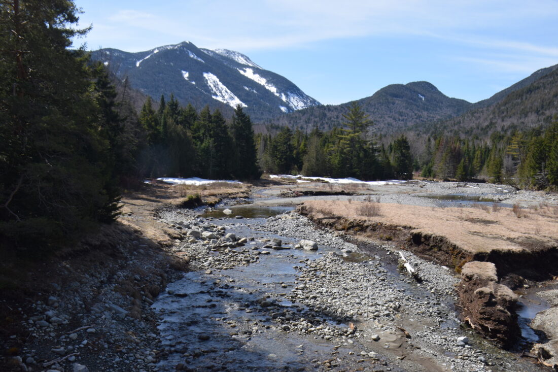
Marcy Brook is seen from the Van Hoevenberg trail's high water bridge near Marcy Dam on Monday, April 14. (News photo — Chris Gaige)
Local News

Boilers keep the maple syrup flowing

Ice goes out on Mirror Lake

Still skiing after all these months
North Elba approves LEAF grants
LAKE PLACID — The North Elba Town Council approved 15 grants on Tuesday, April 8 from the Local Enhancement and ...
Lake Placid school board approves $23.1M budget
LAKE PLACID — The Lake Placid Central School District board voted unanimously on Tuesday, April 8 to approve the ...
